
Sea route planning made simple
Planning the ship’s passage is complex. It has to take into account many different factors to ensure a safe, compliant and efficient voyage. And getting it right can be time consuming.
The OneOcean Passage Planning module – available through the voyage planner tool – makes it simple, quick and accurate. It brings together all the information required to accurately plan the ship’s voyage using intuitive software.
All the necessary data and potential route details are consolidated so that bridge officers can determine the best passage for a vessel on a particular day and conditions – and share it automatically with those leading, managing and monitoring the fleet.
When things change, the Platform enables users to adjust passage plans and when the ship is connected those onshore will know what is happening.
The team behind the software
You can be confident that the information being used is overseen by the biggest, most experienced Data Governance team in the industry, staffed by ex-mariners who know how critical accurate data is to the safety and efficiency of your voyage.

OneOcean’s vessel Passage Planning advantages
Detailed sea route planning in minutes
-
A digitised workflow that saves hours of manual calculations.
-
Efficient chart management – buy charts you need only when you need them: if the route changes, easily add new ones to the passage plan.
-
Passage Planning is the core module for other OneOcean datasets – adding other services gives users a single view of all voyage factors in one window.
Passage planning software you can trust
-
Total compliance at sea – you cannot set sail without a passage plan, and your OneOcean vessel route planner means you comply with maritime regulations, including the SOLAS Convention and SIRE 2.0. Our software also ensures created plans meet bridge procedure guides, navigational requirements, and the STCW Convention.
-
Changes are recorded together with digital signatures, meaning there is a simple audit trail if needed.
-
Unique voyage planning software security and reliability – everything is backed up on board, secure and not dependent on permanent connectivity.
Quick and easy decision making that everyone can see
-
Seamless communication on board and onshore – a time-stamped plan can be saved, approved, exported, recalled for quick usage and modification, and is automatically shared with the shoreside teams.
-
In-voyage assessments and calculations – with continually updated operational and safety events enabling rapid route decisions.
-
Customisable – adjust parameters to meet the demands of your fleet and vessels.
-
Control and consistency across the fleet - the software can be further customised to match company policies, for example for UKC and waypoint tables.
Navigation strategy
Instant planning
Intelligent control
Shared visibility

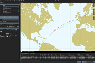
From Rosario to Durban: Passage planning on a complex voyage
Your team needs to plan an ocean passage between Rosario in Argentina and Durban in South Africa for a Handy-size vessel carrying cargo.
This complex voyage spans over 473 waypoints, including a challenging stretch of 314 waypoints along the Paraná River. Navigating this river requires precise planning to handle overhead clearance (OHC) for bridges, limited under keel clearance (UKC) at every waypoint, and narrow navigation channels with reduced cross track distance (XTD) allowances. Further, the vessel must manoeuvre through 138 additional waypoints in shallow waters marked by buoys before reaching open ocean.
The ocean passage involves deciding between a rhumb-line (RL) or a great circle (GC) route across the South Atlantic, weighing factors like fuel consumption, weather conditions, and safety.

Marine passage planning in minutes
Done manually this voyage plan could take days. The Passage Planning module presents options in minutes.
Mariners can toggle on and off the layers of information from other OneOcean datasets, presenting on-screen visualisations of charts, environmental status, weather and more. That allows them to quickly explore alternatives.
The result is effective, detailed voyage planning in one digital workflow. In the Passage Planning software, routes are generated complete with a detailed, customisable waypoints table that can be modified as needed to add safety, compliance and operational events.

Detailed calculations automatically
Those planning this route can trust the software and know a passage plan will be generated in minutes.
- Automated UKC calculations: The Platform automatically calculates UKC for every waypoint, incorporating tidal data and vessel parameters, ensuring safe navigation through the shallow sections of the river and buoys.
- Integrated safety settings: The Platform dynamically incorporates safety parameters such as turning radius limitations, cross-track distance (XTD) allowances, overhead clearance requirements and many more. These features enable precise risk management, particularly in narrow river channels and confined waters. Additionally, the Platform allows for multi-waypoint selection, making it easy to edit multiple waypoints simultaneously, further streamlining the planning process.
- Automated routing adjustments: You can automatically apply a great circle (GC) route if the distance between two waypoints exceeds a predefined limit. This ensures navigational accuracy and efficiency for long legs of a voyage, reducing manual intervention and allowing seamless integration of optimal routing practices into the passage plan.

Onboard and onshore communication
Everyone involved needs to know the plan. That happens automatically.
Once complete, a time-stamped plan can be saved, approved, exported and recalled for quick usage and modification. The shoreside teams can see exactly what is in the voyage plan.
You can also choose to add our Route Optimisation software to make detailed recommendations based on criteria you determine, such as time, cost or fuel efficiency.
Pair Passage Planning with Routing Optimisation
Latest insights

Other solutions you might be interested in
Route Optimisation
Plan optimal routes with integrated tools that combine navigational, weather and regulatory data to support fuel-, time- or cost-efficient routing, mid-voyage flexibility and expert-guided performance advice.
Navigation
Preparing mariners with the insights needed to stay compliant, while safely and efficiently navigating every stage of the journey.
Compliance
Ensure your fleet and vessels always meet regulatory, environmental and reporting requirements with comprehensive maritime compliance software, compiled by the most experienced team in the business.
Operations
Providing the granular detail shoreside teams need to monitor fleet activity in a single view.